Superfund and contaminated sites
Potential impacts to health and home value
8 min read
"Superfund" may be the most confusing term a homebuyer runs into. On its face it has nothing to do with buying a home. But it's worth understanding, both for what it means for your health and for the home's value, so you can find and confirm any sites near a home and weigh them alongside every other consideration. This article explains the term, points to the official sources, and offers a practical way to evaluate Superfund proximity during your home search.
Key Takeaways
- "Superfund" is the trust fund created by 1980 federal law (CERCLA) to finance the cleanup of "abandoned or uncontrolled hazardous waste sites." The worst sites go on the National Priorities List (NPL).
- There are thousands of Superfund sites nationwide, and California has the most among all states.
- A Superfund site may be active, mid-cleanup, or already cleaned up and removed from the National Priorities List.
- Proximity is not necessarily exposure. EPA's proximity metric uses "distance weighted proximity as a proxy for the potential impact."
- California's DTSC EnviroStor lets you look up "all 142 California sites on the federal Superfund cleanup list," each with its cleanup status.
Not all Superfund sites are equal. Learn about them early so you can investigate the real impacts, or simply walk away.
What "Superfund" actually means
Superfund is the nickname for the Comprehensive Environmental Response, Compensation, and Liability Act (CERCLA), enacted by Congress in 1980 to clean up abandoned or uncontrolled hazardous waste sites. When a contaminated site is bad enough, EPA scores it and may add it to the National Priorities List: "the list of sites of national priority among the known releases or threatened releases of hazardous substances." Being on the NPL is what marks a site for long-term, federally financed cleanup.
The NPL is not static. EPA "may delete a final NPL site if it determines that no further response is required to protect human health or the environment," and it can do partial deletions too. A "Superfund site" can be an active, fenced-off problem, or a parcel that was cleaned up years ago and now has a park on it. Distance on a map can't tell those two apart. The status can.
California runs its own cleanup program through the Department of Toxic Substances Control (DTSC), and publishes EnviroStor, its "data management system for tracking cleanup… at hazardous waste facilities and sites with known contamination," covering the state's federal Superfund sites plus thousands of state-tracked sites.
Proximity is a signal for deeper investigation
Being near a Superfund site does not necessarily lead to a health impact. Per the federal health agency for toxic sites, ATSDR, a health impact requires a "completed exposure pathway" made of five elements: a contaminant source, a way for it to travel, a point where people contact it, a route into the body, and people there to be exposed. Living near a site is one piece of that puzzle, and often the most critical link in the chain.
And ATSDR is careful even then: "A completed exposure pathway does not mean that the exposure will result in harmful health effects." EPA is just as candid about distance: its Superfund indicator "uses distance weighted proximity as a proxy for the potential impact." So "a Superfund site is a mile away" really reads as: a site exists nearby, go check its status and whether a pathway to this home is even plausible.
The two pathways worth understanding for a home are groundwater and vapor intrusion. Groundwater is the most common problem at these sites, addressed at approximately 85 percent of NPL sites where EPA selected remedies. This matters most if a home draws well water rather than treated municipal supply. Vapor intrusion "occurs when there is a migration of vapor-forming chemicals from any subsurface source into an overlying building," and whether it's a problem is deeply building-specific.
How to read it for a specific address
National Superfund sites and hazardous waste sites are public information, accessible through official government websites:
- EPA's "Search for Superfund Sites Where You Live" — search by city, county, ZIP, or NPL status. Click a site to open its profile page, which shows the cleanup status and the contaminants involved. EPA's "Cleanups in My Community" map plots them.
- California DTSC EnviroStor — look up a location and read each site's cleanup status and type. It's linked to the state's groundwater database, so it's the place to check the California-specific picture.
Treat these as screening tools. A nearby site and its distance are signals for further research, its status, contaminant types, and site history, or, for the most risk-averse buyers, a signal to walk away.
What it costs
Unlike hazards such as flood or wildfire, a Superfund site carries no mandatory insurance to cover "damage," so there's no extra insurance line to budget for. The real impact isn't physical damage to the property; it's to health and resale value, and it can take years to surface.
A Superfund site is a serious health hazard, which is the reason EPA created the program, and it's a common worry for health-conscious buyers. Many will simply walk away from a home with a site nearby. That's exactly why resale value belongs in the decision: even if you're comfortable with a home you like, a share of future buyers won't be.
How to deal with it
If a home you like sits near a Superfund site, here's the playbook:
- Identify the specific site and its status (EPA site search + DTSC EnviroStor). Active vs. cleaned-up changes everything.
- Pause and weigh it. How much you like the home decides how far you're willing to investigate.
- Research the contamination, controls, and site history. A non-migrating, well-controlled, cleaned-up site is far less concerning than an active one.
- Ask about institutional controls: land use covenants or deed restrictions on the parcel and its neighbors.
- Consult professionals: an environmental consultant or geologist for the assessments, a real-estate attorney for the covenants and disclosures.
How OpenHomeVue helps
OpenHomeVue reads the same EPA EnviroFacts data the federal tools draw on and turns it into a plain-language chip on every property's Key Considerations card: Superfund Proximity, showing how many EPA Superfund sites sit within three miles. And it doesn't stop at counting: the chip's color reflects cleanup status, flagging when a nearby site is still active versus already cleaned up or deleted from the list, which, as the agencies themselves stress, is the fact that actually matters.
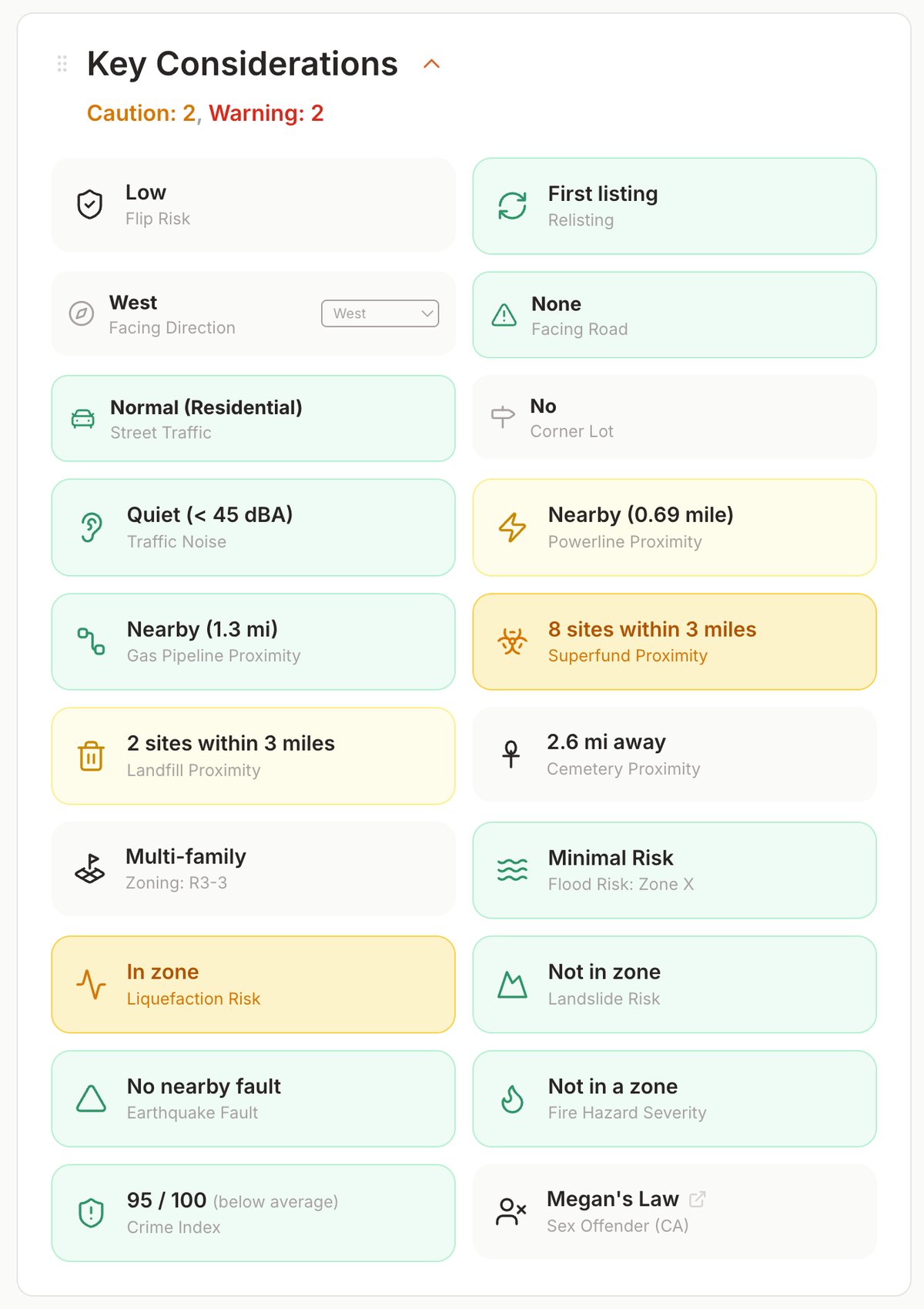
Every property gets a Key Considerations card; here the Superfund Proximity chip shows how many EPA Superfund sites sit within three miles, color-coded by cleanup status.
A map overlay plots the nearby sites so you can see where they sit relative to the home, across your whole shortlist. We're deliberate about what this is: a screening signal, a prompt to open EPA's site profile or DTSC EnviroStor and check the specific site. It is not an exposure or health assessment, and it doesn't model whether anything reaches a given home. What it does is make "there's a site nearby, what's its status?" a question you ask on day one.
And when a site is close enough to matter, the map's measure tool turns proximity into a concrete number. Draw a line from the home to a specific site, an active one especially, and read the straight-line distance directly off the map, so "a Superfund site is nearby" becomes an exact distance you can weigh, not a vague worry.
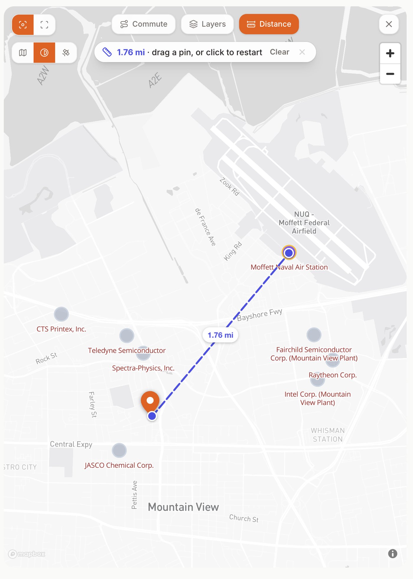
The map's measure tool drawing the straight-line distance from the home to a nearby active Superfund site, turning proximity into an exact number.
References
- U.S. EPA, Superfund: CERCLA Overview
- U.S. EPA, Superfund: National Priorities List (NPL)
- U.S. EPA, Basic NPL Information (Hazard Ranking System)
- U.S. EPA, Superfund: National Priorities List Deletion
- U.S. EPA, Search for Superfund Sites Where You Live
- U.S. EPA, Cleanups in My Community
- U.S. EPA, How Superfund Addresses Groundwater Contamination
- U.S. EPA, About Vapor Intrusion
- U.S. EPA, Vapor Intrusion at Superfund Sites
- U.S. EPA, EJScreen (Superfund proximity as a proxy)
- U.S. EPA, Envirofacts
- ATSDR (CDC), Exposure Pathway Categories (completed / potential / eliminated)
- ATSDR (CDC), Overview of the Exposure Pathway Evaluation
- ATSDR (CDC), Public Health Assessment Guidance
- California DTSC, Your EnviroStor / EnviroStor public search
- California DTSC, Land Use Covenants (deed restrictions / institutional controls)
All sources are U.S. federal (EPA, ATSDR/CDC) or California state (DTSC) government agencies and their official tools.
Updated Jul, 2026