Landslide
Breathtaking views, not breathtaking cost
8 min read
Hillside homes are often prized for their breathtaking views, but the insight that matters most, whether the lot sits on a stable slope, usually isn't available until late, or only after deep research. Part of the reason is that the answer is multi-faceted, with no simple yes or no. The hardest part is knowing how to find and read that data to inform your decision. This article demystifies landslide risk: how to read the zone, what it costs, and what it does not cover, so you know what's left to check yourself.
In California, the state maps the most critical type, earthquake-induced landslide zones, and requires sellers to disclose when a home sits in one. The catch is on the cost side: standard insurance mostly excludes landslide, so the bill lands on you.
Key Takeaways
- California's Seismic Hazards Mapping Act draws regulatory earthquake-induced landslide "zones of required investigation," and mandates seller disclosure if a home is in one.
- Standard insurance policies "do not cover damage from natural disasters such as earthquakes, floods, and landslides." Landslide coverage requires a separate, specialty policy.
- Rainfall and post-fire debris flows are a separate hazard the seismic zones don't capture (covered below, with where to look).
A breathtaking view needs stable ground to support it. Start with the seismic landslide zone, then evaluate rainfall and post-fire debris flow to build fuller assurance.
What "landslide" actually means
Landslides are "the downslope movement of earth materials (rock, debris, and soil) at rates that range from inches per year to tens of miles per hour." For a home buyer in California, the one that's mapped and disclosed is the earthquake-induced landslide.
Earthquake-induced landslides are slope failures triggered by ground shaking. California maps these as regulatory zones: "A Seismic Hazard Zone is a regulatory zone that encompasses areas prone to liquefaction… and earthquake-induced landslides," and the mapping "incorporates expected future earthquake shaking, existing landslide features, slope gradient and strength of hillslope materials." Because it's a regulatory zone, it shows up on the state's map and on the disclosure packet, which is what makes it checkable before you tour.
Landslides also include rainfall and post-fire debris flows. Debris flows are "fast-moving landslides… particularly dangerous to life and property because they move quickly, destroy objects in their path, and often strike without warning." They "can travel at speeds up to and exceeding 35 mph and can carry large items such as boulders, trees, and cars," usually during intense rainfall.
Landslides can cause serious damage to a home: they "can bury homes, damage critical infrastructure, block or damage roads… and disrupt vital utilities." Even a slide downhill of your house is a warning, since "large cracks can form in yards… indicators of potential additional movement and increased landslide risk."
Why it matters in California
California stacks the deck for landslides: widespread steep terrain, and a climate that swings between wildfire and atmospheric-river storms. The Seismic Hazards Mapping Act of 1990 directs the state to delineate "zones of required investigation" for earthquake-induced landslides, and requires that "cities and counties… use the Seismic Hazard Zone Maps in their land use planning and building permit processes." If a home is in one of these zones, a site-specific geologic investigation is required before development, and the seller must disclose the zone to home buyers.
How to read it for a specific address
For the mapped, checkable case, two free tools and one document:
- EQ Zapp: the California Geological Survey's free map "allows anyone with a computer, tablet or smartphone to conveniently check whether a property is in an earthquake hazard zone." Type an address; it shows fault, liquefaction, and earthquake-induced landslide zones. → conservation.ca.gov/cgs/geohazards/eq-zapp
- Cal OES MyHazards: a friendly multi-hazard starting point by address. → myhazards.caloes.ca.gov
- The disclosure (NHD) statement: California's Natural Hazard Disclosure has a dedicated seismic-hazard line with a Landslide Zone box: "A SEISMIC HAZARD ZONE pursuant to Section 2696… Yes (Landslide Zone)… Yes (Liquefaction Zone)… No… Map not yet released by state."
The caveat: an unmapped address is not proven safe, and a green "not in a zone" on EQ Zapp clears only the earthquake-induced case.
What it costs
Insurance, the part that surprises people. Standard homeowners, renters, and condo policies "do not cover damage from natural disasters such as earthquakes, floods, and landslides." And the gaps don't stop there: a federal flood policy "excludes losses caused by earth movement, even if the earth movement is caused by flood," and "Landslide, slope failures, or saturated soil moving down a slope are not mudflows." In plain terms: homeowners excludes landslide, an earthquake policy is built for shaking rather than a rainfall slide, and flood insurance covers a water-borne mudflow but not a mudslide. Covering this peril often means a specialty "difference-in-conditions" policy, which can be hard to get on known-unstable ground.
Geotechnical and stabilization. In a mapped earthquake-induced landslide zone, before development "cities and counties must require a site-specific investigation to determine whether a significant hazard exists at the site." That means a licensed geologist or geotechnical engineer's report, and if the slope needs work, stabilization (retaining walls, soil nails, drainage, re-grading) is major-construction money. Costs vary too much site-to-site for a single figure, which is exactly why the report comes first.
How to deal with it
If a hillside home you love sits in (or below) a zone, here's the playbook:
- Check the zone early. Pull the earthquake-induced landslide zone before you tour (EQ Zapp, Cal OES MyHazards, or OpenHomeVue). For a fire-prone slope, also check the debris-flow sources above.
- Read the soils report, and consider your own. In a mapped zone a geotechnical investigation is already required for development; commission your own assessment if the disclosure leaves questions.
- Manage water and slope. The USGS lists "channeling water onto a slope" and grading as human triggers, so drainage control and slope maintenance are core, ongoing mitigations.
- Insure deliberately. Don't assume you're covered. Price a specialty earth-movement / difference-in-conditions policy, and confirm in writing what's excluded.
- Heed the warnings. During atmospheric-river storms on or below burn scars, National Weather Service debris-flow warnings are not background noise.
How OpenHomeVue helps
OpenHomeVue reads the California Geological Survey's Seismic Hazards Mapping Act data and turns the earthquake-induced landslide zone into a plain-language status on every property you're considering. The Landslide Risk chip on the Key Considerations card reads In zone, Not in zone, or Not evaluated where the state hasn't mapped the area, so there's no guessing and no false "all clear."
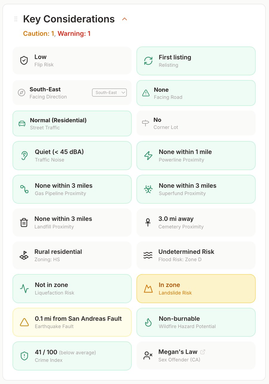
Every property gets a Key Considerations card; here the Landslide Risk chip flags an earthquake-induced landslide zone ("In zone").
There's also a map overlay that draws those landslide zones right onto the property map, so it's something you see on day one, across your entire shortlist, not on a late page of a disclosure packet. One honest boundary: this chip and overlay reflect the state's earthquake-induced landslide zones. Rainfall-driven and post-fire debris-flow hazards are a separate question, covered in "What this doesn't cover" above.
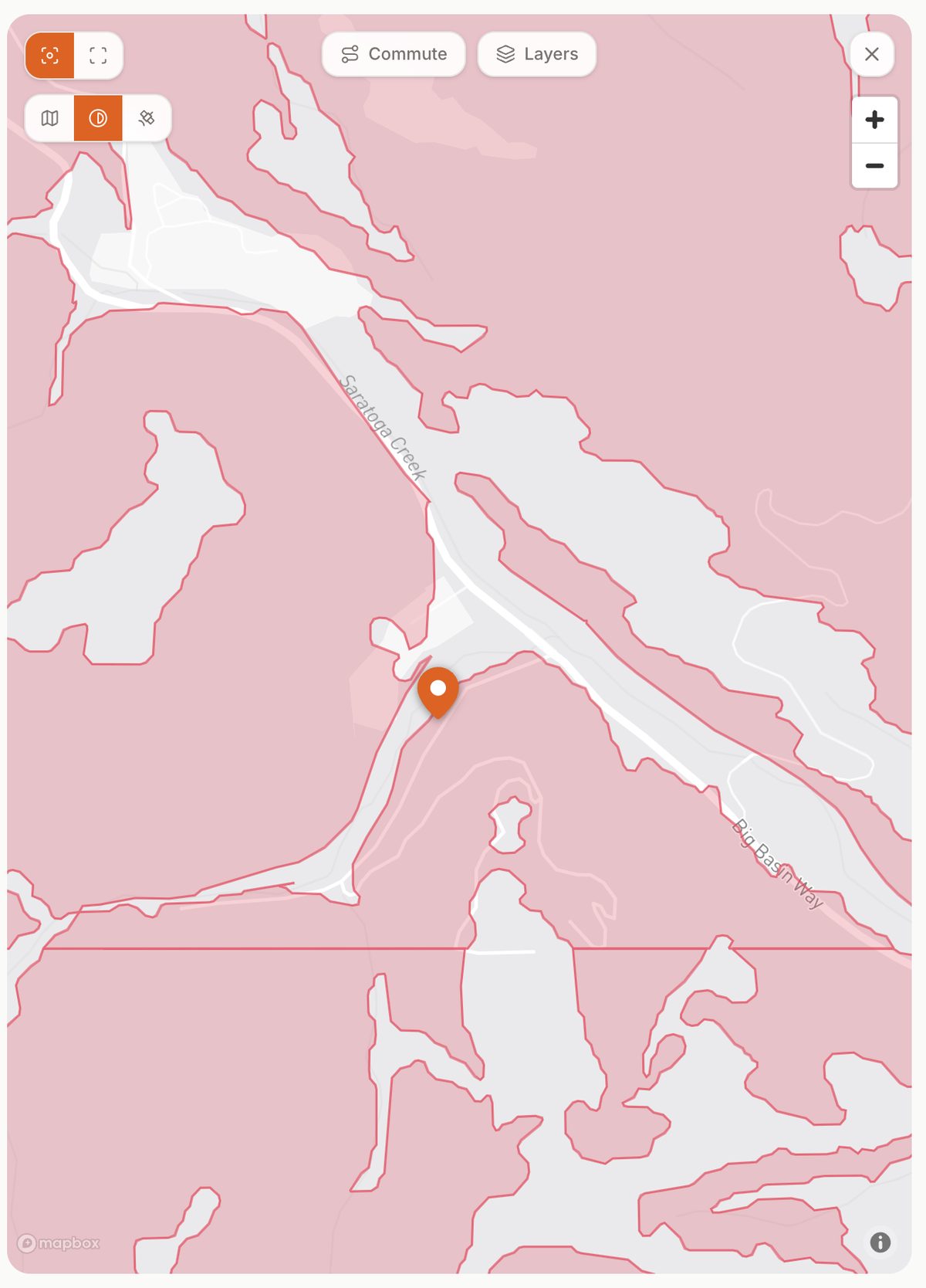
The same property's earthquake-induced landslide zone on the map overlay, so you can see whether the home sits inside a mapped zone or just near its edge.
References
- California Geological Survey, Seismic Hazard Zones (earthquake-induced landslide zones)
- California Geological Survey, EQ Zapp earthquake hazards zone application
- California Geological Survey, Landslide Inventory & Deep-Seated Landslide Susceptibility map
- California Geological Survey, Map Sheet 58: Susceptibility to Deep-Seated Landslides in California
- U.S. Geological Survey, What are landslides & how can they affect me?
- U.S. Geological Survey, What is a debris flow?
- U.S. Geological Survey, Postfire debris-flow hazards
- California Governor's Office of Emergency Services (Cal OES), MyHazards
- California Department of Insurance, Earthquake Insurance (homeowners exclusions)
- California Department of Insurance, Flood Insurance Resources (earth-movement / mudflow vs. mudslide)
- California Civil Code, §1103.2, Natural Hazard Disclosure Statement (Landslide Zone checkbox)
All sources are U.S. federal (.gov) or California state (.ca.gov) government agencies.
Updated Jun, 2026