Gas Pipelines
Know where the big lines run before you tour
11 min read
Not every homebuyer checks gas pipelines near a home they like, but those who do have the same picture in mind: San Bruno, 2010, a suburban block gone in an afternoon. It is a real event and a fair fear. It is also, statistically, among the rarest ways a pipeline will ever touch your life as a homeowner.
The likelier ways are quieter: a recorded easement that vetoes the ADU you were planning, an operator's mowing crew with legal access to your back yard, a next buyer who asks the question you didn't. This article sorts the rare-but-severe from the common-but-manageable, and shows how to check any address before you fall for the house.
Key Takeaways
- Not all gas lines are alike. Transmission lines are the large, high-pressure corridors (most are 6–48 inches, roughly 200–1,500 psi); distribution lines are the small, low-pressure pipes already serving nearly every home, including yours. The big question is about the big transmission pipelines.
- Serious pipeline incidents are rare: across 3.3 million miles of U.S. pipelines, 2014–2024 averaged 11 deaths and 26 serious incidents a year. But transmission failures are high-consequence when they happen: the San Bruno rupture killed 8 people and destroyed 38 homes.
- The measurable price story is calmer than the fear: studies of actual sales find no systematic discount for quiet proximity to a buried line; what moves prices is a nearby incident, a real but localized and fading hit.
- The everyday reality is the easement: no permanent structures on the right-of-way, operator access to the land, and it binds every future owner. It is in the title, which means you can read it before you offer.
A transmission line nearby is a mapped, titled, checkable fact, and the buyers it hurts are the ones who learn about it in escrow instead of before the tour.
The pipes under every street vs. transmission lines
Here is the fact that reframes the whole topic: if the home has gas service, there is already a gas pipe within a few feet of it. The U.S. runs on about 2.35 million miles of distribution lines, the small, low-pressure pipes that branch to every meter, and about 299,000 miles of transmission lines, the interstate-highway tier that moves gas across regions at high pressure.
When buyers worry about "a pipeline," the biggest concern is the transmission pipelines: steel lines up to four feet across, operating at hundreds of pounds of pressure, running in their own corridors. Those are the lines that make the news when they fail, the lines on the federal map, and the lines this article is about. The everyday distribution pipes matter too, especially for remodeling or landscaping jobs, but they are everywhere and not as remarkable as the major transmission pipelines.
Why does it matter for California Homebuyers
Federal regulators oversee 3.3 million miles of pipeline. Over 2014–2024, all of it together averaged 11 deaths, 48 injuries, and 26 serious incidents a year nationwide. For scale, that is a vast network with a relatively low serious failure rate, and most of those casualties happen on distribution systems, not the transmission corridors buyers worry about.
However, rare is not never. On September 9, 2010, a 30-inch PG&E transmission line ruptured under a San Bruno neighborhood: 8 killed, 38 homes destroyed, 70 more damaged. The NTSB traced it to a defective 1956 seam weld that the operator's records and inspections had never caught. Both halves are true at once: the odds are very low, but the worst case is severe.
California rebuilt a lot of its safety architecture on that lesson. The state fined PG&E $1.6 billion and passed the Natural Gas Pipeline Safety Act of 2011; the utility's resulting program installed 217 automated shutoff valves and strength-tested over 673 miles of pipe. A buyer near a California transmission line today is looking at a system under materially heavier scrutiny than the one that failed in 2010.
Potential Impact Radius (PIR) is a term to get familiar with on this topic: a federal formula (49 CFR 192.903) that scales with a line's diameter and pressure. A 30-inch line at 1,000 psi works out to roughly 655 feet; the largest lines at full pressure reach about 1,100 feet.
PIR is not a guarantee of safety. The PIR exists to tell operators where extra inspection is required: where a circle around the line contains 20 or more occupied buildings, the segment becomes a "High Consequence Area" with stricter integrity rules. It is not a habitability line, and it is not a guarantee: San Bruno's line computed to about 415 feet, and the actual fire reached beyond typical lot distances. Treat PIR as a sense of scale for how big the planning circle around a major line is, not a safety boundary.
What it costs
Weak impact on property price
For plain proximity, there is "no systematic evidence, based on actual sales data, that proximity to pipelines reduces property values," and no measurable price or insurability impact. Disclosure matters on both: the review adapted work funded by a pipeline company, and the paired-sales study was industry-funded. Their conclusion, though, matches what independent academics find when they look at installation alone.
The exception is an incident. A 2024 nationwide academic study of 234 gas pipeline incidents found homes within a few hundred meters lost about 12.4% of value in the first year and a half after a nearby failure, more after explosions or evacuations, with the effect fading over time. The same study found that the mere presence of a new pipeline had no statistically significant price effect.
The insight for a buyer: the market does not punish a quiet buried line, so do not expect a "pipeline discount" on a normal listing. What carries risk is the low-probability event and its aftermath, which is a risk you size up with the safety facts above, not with price data.
The easement is the everyday reality
Statistically, the way a transmission line actually enters a homeowner's life is on paper. The line sits in a recorded easement, a right-of-way that runs with the land and binds every future owner. In practice that means:
- No permanent structures on the right-of-way. No addition, garage, ADU, or pool over the corridor, and restrictions on deep-rooted trees. If your plans for the property involve building, this is the first thing to check.
- Operator access. The company can enter to inspect, mow, and maintain its line. A well-kept ROW is a safety feature; it is also someone else's crew in your yard on their schedule.
- Digging rules. Any digging near a line starts with a free call to 811 a few days ahead, so utilities can mark what is buried. That is true at every house, but the stakes are higher on a transmission corridor.
None of this is hidden. The easement's exact terms are in the recorded documents and the preliminary title report, which you or a real-estate professional can read before you commit.
How to check a specific address
- Look at the federal map. PHMSA's National Pipeline Mapping System public viewer shows gas transmission and hazardous-liquid lines county by county, and its "Find Who's Operating in Your Area" tool gives you the operator's contact. Know its limits: it does not show distribution or gathering lines, and it is deliberately not parcel-precise.
- Walk the route. Transmission corridors are marked with above-ground line markers at roads and intervals. On a tour, a marker on the block tells you more than an afternoon online.
- Pull the title. The preliminary title report and recorded easements answer the questions that actually bind you: does a ROW touch this parcel, how wide is it, and what does it prohibit?
- Ask the operator the line-specific questions. Diameter, operating pressure, inspection method and date. Operators run public-awareness programs for exactly this, and the federal guidance model is consultation, not distance.
How to deal with it
A mapped transmission line within a mile or so of a home you like is common and, most of the time, a non-event. When one is close:
- Sort your worry into the two real buckets. Safety: rare, severe, and mostly outside your control beyond choosing distance. Practical: the easement, which is fully knowable before you offer. Spend your diligence on the second.
- If the ROW touches the parcel, read it before you commit. The easement decides your pool, your ADU, and your landscaping. A real-estate attorney's hour here is cheap insurance.
- The market does not price your fear. Sales data show no systematic discount for quiet proximity, so neither your purchase price nor your resale is likely to carry one. Negotiate on the easement's actual restrictions if they bite, not on the line's existence.
- If the risk still sits wrong with you, prefer distance. That is a legitimate preference. The value of knowing early is that you can act on it before the emotional deposit is made, not after.
How OpenHomeVue helps
The pipeline question is a perfect example of a check that is easy once someone runs it for you and tedious otherwise. OpenHomeVue runs it on every property you save: the Key Considerations card's Gas Pipeline Proximity chip reads the distance from the home to the nearest major transmission line in plain language, such as Close (650 ft), Nearby (1.2 mi), or None within 3 miles. The color carries the judgment call: it flags red inside roughly 650 feet, the range where you should be reading easements and asking the operator questions, and amber out to about a third of a mile.
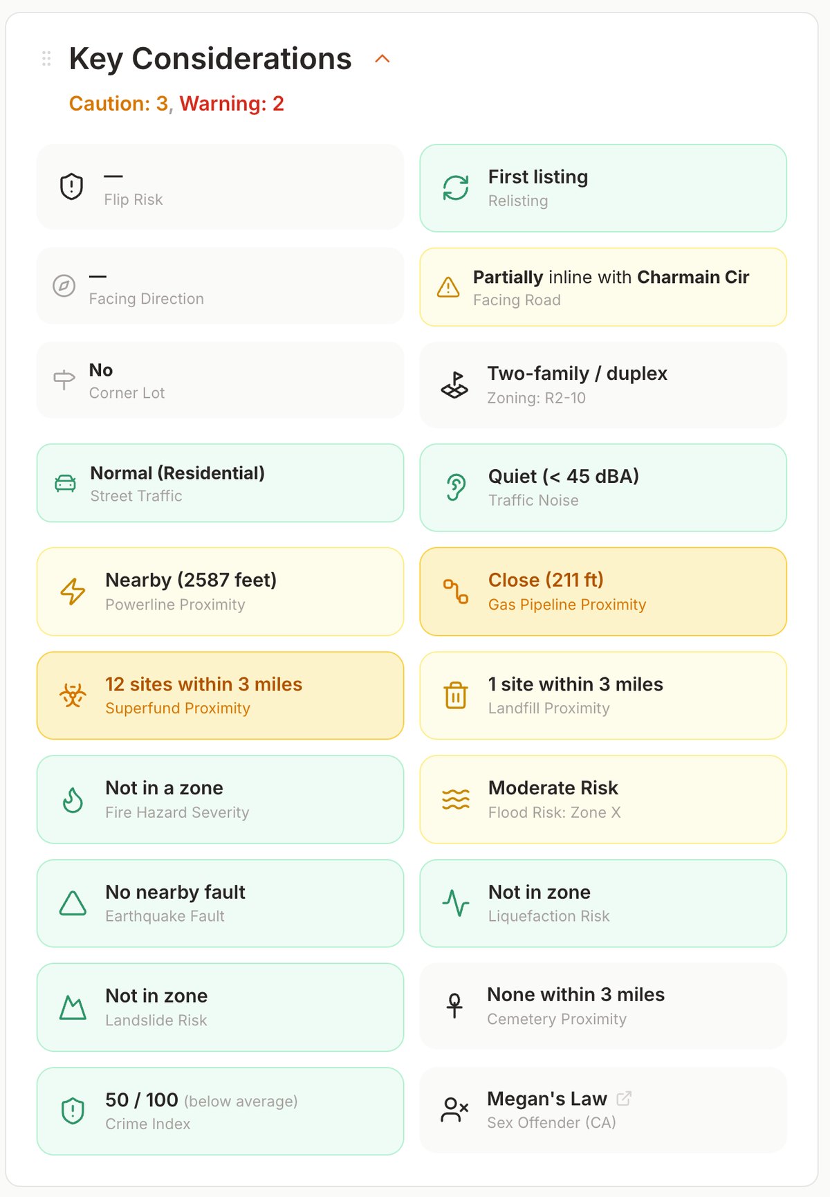
Every property gets a Key Considerations card; here the Gas Pipeline Proximity chip reads the distance to the nearest major transmission line, color-coded by how close it runs.
The map overlay draws the transmission lines around the property, so you can see whether the corridor runs behind the fence line or across town, and the measuring tools let you check the distance from the lot to the line before you spend a Saturday driving out.
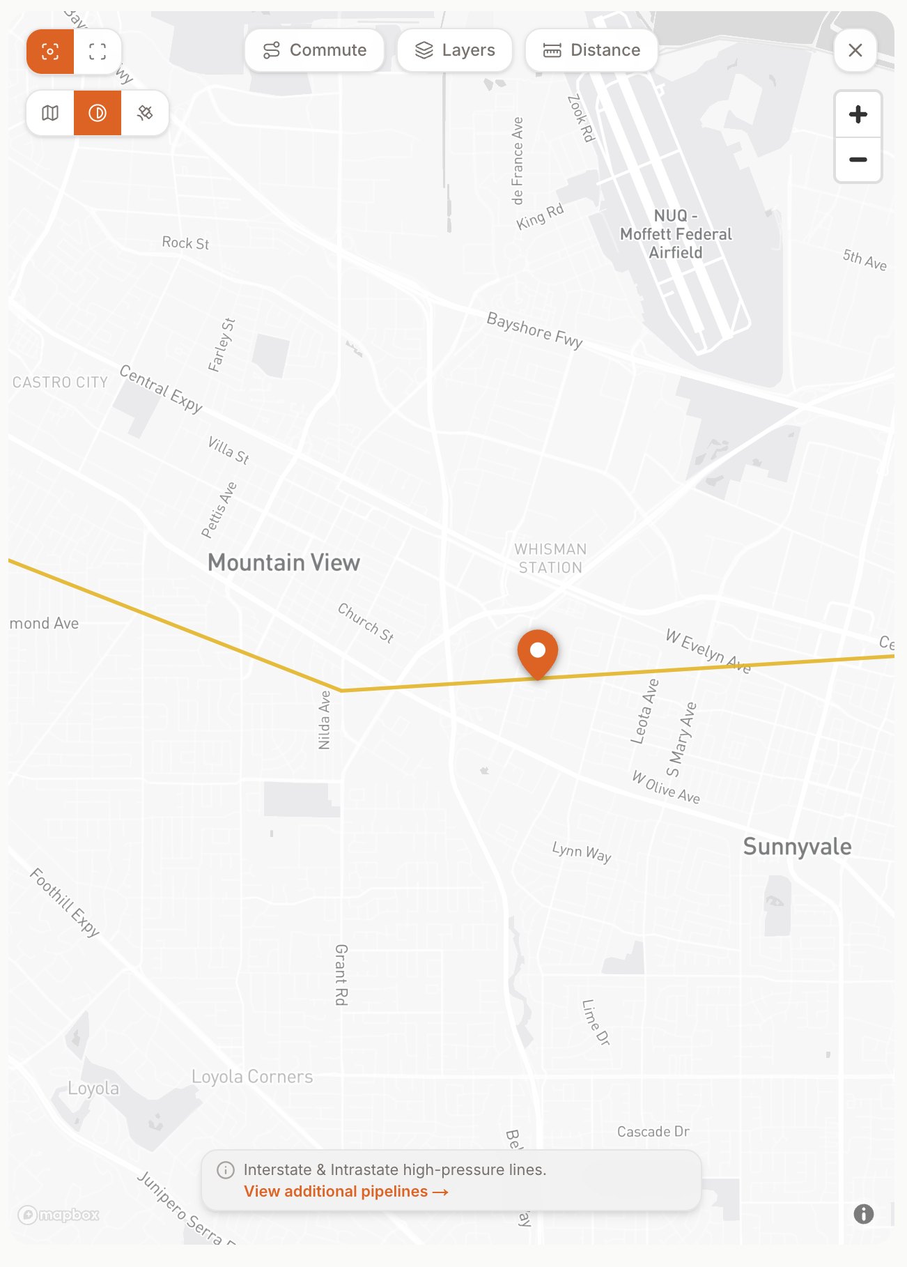
The same property's nearby transmission lines on the map overlay, so you can see whether the corridor runs behind the fence line or across town.
Note: the data OpenHomeVue uses comes from the U.S. Energy Information Administration's dataset of major natural gas transmission pipelines, interstate and intrastate. It does not include distribution or gathering lines (no public map does), and it is a national-scale dataset, not a survey. So read None within 3 miles as "no major transmission line in the federal data," and treat a flagged line as an early prompt to verify with the NPMS map, the title report, and your own eyes, not as a final measurement.
References
- Congressional Research Service, DOT's Federal Pipeline Safety Program: Background and Issues for Congress, R44201 (2025)
- NTSB, Pacific Gas and Electric Company Natural Gas Transmission Pipeline Rupture and Fire, San Bruno, California, September 9, 2010 (DCA10MP008)
- California Public Utilities Commission, San Bruno Incident and Penalty; Gas Safety and Reliability Branch
- 49 CFR §192.903, Definitions: Potential Impact Radius, High Consequence Area
- PHMSA, National Pipeline Mapping System Public Viewer; About the Public Viewer
- PHMSA, Partnering to Further Enhance Pipeline Safety in Communities Through Risk-Informed Land Use Planning (PIPA report, 2010)
- Pipeline Safety Trust, Pipeline Basics and Specifics About Natural Gas Pipelines, Briefing Paper #2 (2024); Pipeline Info for Landowners and Residents
- Wilde, Loos & Williamson, Pipelines and Property Values: An Eclectic Review of the Literature, Journal of Real Estate Literature 20(2), 2012
- Cheng, Li, Liu, Luo, Tang & Zhang, Pipeline Incidents and Property Values: A Nationwide Hedonic Analysis (Journal of Environmental Economics and Management, 2024)
- INGAA Foundation / Integra Realty Resources, Pipeline Impact to Property Value and Property Insurability (2016)
- Common Ground Alliance, 811: Call Before You Dig
- U.S. Energy Information Administration, Natural Gas Interstate and Intrastate Pipelines dataset
Primary sources are U.S. federal (CRS, NTSB, PHMSA, Code of Federal Regulations, EIA) or California state (CPUC) government agencies. The Pipeline Safety Trust is a safety nonprofit created after a fatal 1999 pipeline accident. On property values: the literature review adapted work funded by a pipeline operator and the INGAA study is industry-funded, both noted in the text; the 2024 incident study is independent academic research. Pipeline locations shown in the app come from the EIA's public dataset of major transmission lines; it does not include distribution or gathering lines.
Updated Jul, 2026