California Wildfire Risk
Be Aware and Be Prepared
9 min read
A home closer to nature, with trees, views, and a large lot, is very appealing to California homebuyers. It also comes with a real risk, given California's dry weather through most of the year: wildfire. No one wants to lose a home, and most importantly their belongings and memories, to fire. Having insurance doesn't change that feeling: even a fully covered total loss still means a large deductible, months or years living somewhere else while you rebuild, the ordeal of settling a claim, and possessions that no payout brings back.
So the question worth asking early is a plain one: how likely is this area to burn? California answers it with an official measure, the Fire Hazard Severity Zone. This article explains what that zone means, how to check it for a specific home, and what you can do about it, so you can weigh the risk before you tour, not after you have invested time and effort in the house.
Key Takeaways
- A Fire Hazard Severity Zone (FHSZ) is California's official rating of how likely an area is to burn, in three levels: Moderate, High, and Very High. Cal Fire and the Office of the State Fire Marshal designate and publish them.
- The zone rates the area's hazard (vegetation, terrain, fire weather, and wind-blown embers), not a verdict on one house. A hardened home in a high zone can fare far better than an unprepared one nearby.
- Being in a zone brings legal duties that also protect the home: defensible space out to 100 feet, and, for new construction, wildfire-resistant building standards.
- Standard homeowners insurance does cover wildfire, but in high-hazard areas the harder problem has become keeping a policy at all, as non-renewals push owners onto the state's FAIR Plan.
Being in a zone is not necessarily a deal-breaker. Knowing early lets you weigh the home, harden it, and price the risk before you commit.
What a Fire Hazard Severity Zone actually is
A Fire Hazard Severity Zone is a rating of how likely an area is to burn, based on the physical conditions that drive wildfire: the vegetation that fuels it, the slope and terrain that speed it, the local fire weather, and the wind-blown embers that carry it. Cal Fire's Fire and Resource Assessment Program and the Office of the State Fire Marshal map and publish the zones in three levels: Moderate, High, and Very High.
Two distinctions matter for a buyer. First, the map covers different responsibility areas: a State Responsibility Area (SRA), where Cal Fire is the primary agency for wildfire protection, a Local Responsibility Area (LRA) covered by a city or county, and federal land. Which one a home sits in affects who protects it and which rules apply. Second, and more important, the zone measures the hazard of the area, not the fate of a specific house. As with a seismic zone, being in a Very High zone does not mean a home will burn, and hardening changes the odds. California recently refreshed these maps: the SRA maps took effect April 1, 2024, and the LRA maps rolled out in March 2025.
Why it matters in California
Most homes lost in a wildfire are not consumed by a wall of flame. They ignite from wind-blown embers that land on a roof, blow into a vent, or catch dry leaves against the wall, often well ahead of the fire front. That is the core idea behind California's home-hardening guidance: the interface between homes and wildland vegetation, what agencies call the Wildland-Urban Interface, is where structure loss concentrates, and small details on the house decide a lot.
That is also why the zone carries legal weight. In higher-hazard areas the state requires defensible space around the home and, for new construction, wildfire-resistant building standards (California Building Code Chapter 7A), which set minimum standards for a building to resist flames and embers from a vegetation fire. These are covered below. The point for a buyer is that the zone is not just a label. It shapes what a home must do to protect itself, and what it will cost to own.
How to read it for a specific property
Wildfire hazard is public information, accessible through official government websites:
- The FHSZ Viewer. Cal Fire and the Office of the State Fire Marshal publish an address-searchable Fire Hazard Severity Zone map, where you can enter an address and see whether it falls in a Moderate, High, or Very High zone.
- The disclosure (NHD) statement. California's Natural Hazard Disclosure has Yes/No checkboxes for whether a property sits in a Very High Fire Hazard Severity Zone and in a State Responsibility Area. Sellers are obligated to provide it.
What it costs
The real cost of wildfire is not the premium, it is the loss. Even a fully insured total loss still means a large deductible, months or years living somewhere else while a home is rebuilt, the slow work of settling a claim, and the things that no payout replaces.
Insurance is the second layer, and in California it has become a real one. Unlike earthquake or flood, standard homeowners insurance does cover wildfire, so the problem is not the peril, it is getting and keeping a policy in a high-hazard area. Insurers have been non-renewing homes in fire-prone areas, pushing owners onto the California FAIR Plan, the state's insurer of last resort established in 1968, which the Insurance Commissioner says "has become the only option for insurance, not the last resort." FAIR Plan coverage is typically more limited and more expensive. And because a mortgage lender requires insurance, a home you cannot insure affordably can stall the purchase itself. So price coverage early, alongside the home, not after the offer.
How to deal with it
If a home you like sits in a high-hazard zone, the hazard is set by nature, but how the home meets it is not. Here is what to weigh:
- Check the zone early (the FHSZ Viewer, or OpenHomeVue, below), before you tour.
- Harden the home against embers. Because embers cause most structure losses, the highest-value steps are a Class A fire-rated roof, ember-resistant vents, multi-pane windows, and keeping the first five feet around the house clear of anything that burns, the ember-resistant "Zone 0" area California is now finalizing. See Cal Fire's home-hardening guidance.
- Create defensible space. In the State Responsibility Area or a Very High zone, Public Resources Code 4291 requires 100 feet of defensible space, managed vegetation in zones out from the house, so a fire has less to feed on as it approaches.
- Use the insurance lever. California's Safer from Wildfires rules require insurers to offer discounts for these same measures, and you can ask your insurer for your wildfire risk score and how to lower it. The reward for hardening is both lower risk and, potentially, a more insurable home.
- Get a quote, and negotiate. Price coverage before you commit, and treat zone status as a legitimate reason to negotiate.
How OpenHomeVue could help
OpenHomeVue pulls the same Cal Fire Fire Hazard Severity Zone data the official maps draw on and turns it into a plain-language status on every property you are considering: Fire Hazard Severity, reading Moderate, High, or Very High, or the distance to the nearest zone when a home sits just outside one, color-coded so a high-hazard home stands out across your whole shortlist.
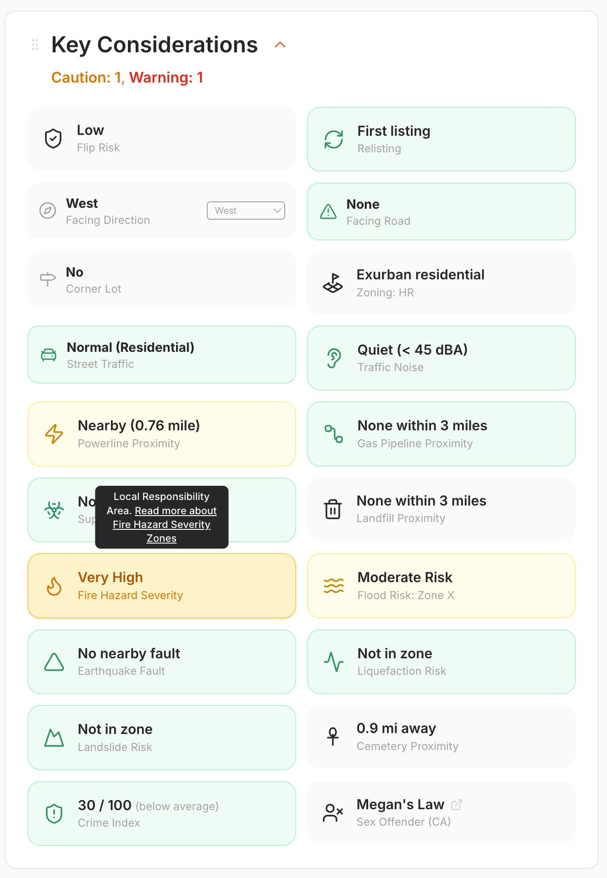
Every property gets a Key Considerations card; here the Fire Hazard Severity chip reads the home's Cal Fire FHSZ class (Moderate / High / Very High), or the distance to the nearest zone.
A map overlay draws the three zone classes (Moderate, High, and Very High) around the home, so you can see whether it sits deep in a zone or near its edge.
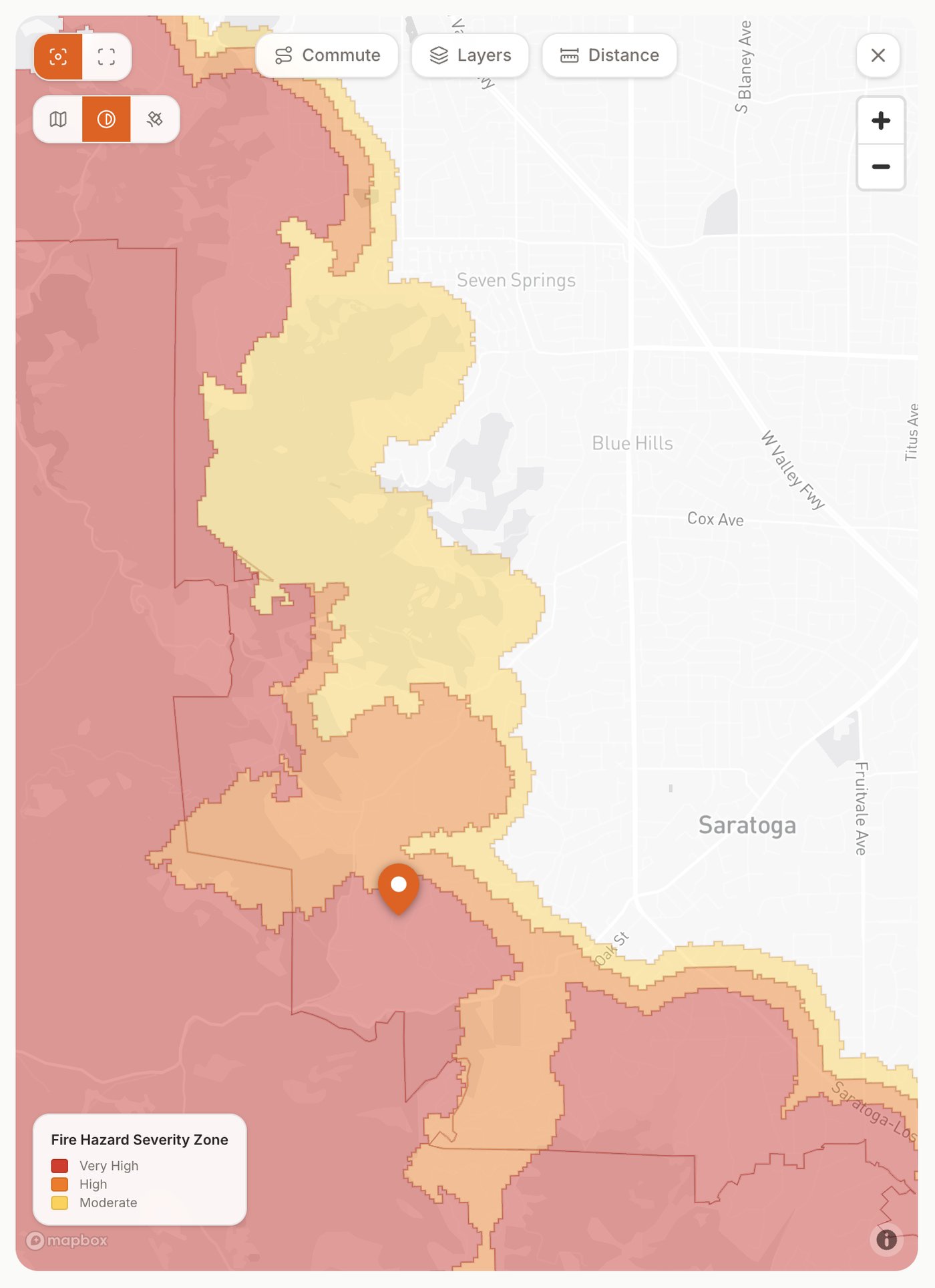
The same property's Fire Hazard Severity Zones on the map overlay (Moderate, High, Very High), so you can see whether the home sits deep in a zone or near its edge.
The difference from a disclosure packet is when and where you see it. Instead of a checkbox buried in a PDF after you have fallen for the house, it is on the map, on day one, across your entire shortlist. And where a home sits outside a mapped zone, we show how close the nearest one is.
References
- Office of the State Fire Marshal (CAL FIRE), Fire Hazard Severity Zones
- CAL FIRE, Fire and Resource Assessment Program: GIS mapping and data
- Office of the State Fire Marshal (CAL FIRE), Building in the Wildland-Urban Interface (California Building Code Chapter 7A)
- California Board of Forestry and Fire Protection, Defensible Space Zones 0, 1 & 2 (PRC 4291, AB 3074 / SB 504)
- CAL FIRE, Home Hardening
- CAL FIRE Ready for Wildfire, Defensible Space
- California Public Resources Code, §4291 (defensible space)
- California Civil Code, §1103.2, Natural Hazard Disclosure Statement
- California Department of Insurance, Safer from Wildfires
- California Department of Insurance, Sustainable Insurance Strategy (final model evaluation)
- California Department of Insurance, FAIR Plan $1 billion assessment (Feb 2025)
- U.S. Fire Administration (FEMA), What is the Wildland-Urban Interface?
All sources are U.S. federal (FEMA/USFA) or California state (Cal Fire, OSFM, Board of Forestry, Department of Insurance) government agencies and their official tools.
Updated Jul, 2026